
Portal:Andes
The Andes Portal

The Andes (/ˈændiːz/ AN-deez), Andes Mountains or Andean Mountain Range (Spanish: Cordillera de los Andes; Quechua: Anti) are the longest continental mountain range in the world, forming a continuous highland along the western edge of South America. The range is 8,900 km (5,530 mi) long and 200 to 700 km (124 to 435 mi) wide (widest between 18°S and 20°S latitude) and has an average height of about 4,000 m (13,123 ft). The Andes extend from South to North through seven South American countries.: Argentina, Chile, Bolivia, Peru, Ecuador, Colombia and western Venezuela.
Along their length, the Andes are split into several ranges, separated by intermediate depressions. The Andes are the location of several high plateaus—some of which host major cities such as Quito, Bogotá, Cali, Arequipa, Medellín, Bucaramanga, Sucre, Mérida, El Alto and La Paz. The Altiplano Plateau is the world's second-highest after the Tibetan Plateau. These ranges are in turn grouped into three major divisions based on climate: the Tropical Andes, the Dry Andes, and the Wet Andes.
The Andes Mountains are the highest mountain range outside Asia. The highest mountain outside Asia, Argentina's Aconcagua, rises to an elevation of about 6,961 m (22,838 ft) above sea level. The peak of Chimborazo in the Ecuadorian Andes is farther from the Earth's center than any other location on the Earth's surface, due to the equatorial bulge resulting from the Earth's rotation. The world's highest volcanoes are in the Andes, including Ojos del Salado on the Chile-Argentina border, which rises to 6,893 m (22,615 ft). (Full article...)
Selected articles
-

Cerro del Nacimiento is an Andean volcano of the Cordillera de la Ramada range, in the Catamarca Province of Argentina. Its summit is 6,436 metres (21,115 ft) above sea level. (Full article...) -
Tupungato, one of the highest mountains in the Americas, is a massive Andean lava dome dating to Pleistocene times. It lies on the Argentina–Chile border, between the Chilean Metropolitan Region (near a major international highway about 80 km (50 mi) east of Santiago) and the Argentine province of Mendoza, about 100 km (62 mi) south of Aconcagua, the highest peak of both the Southern and Western hemispheres. Immediately to its southwest is the active Tupungatito volcano (literally, little Tupungato), which last erupted in 1987.
Tupungato Department, an important Argentine wine-producing region in Mendoza province, is named for the volcano. Recent Chilean mapping indicates it has a height of 6635m. (Full article...) -
Chinchillas are either of two species (Chinchilla chinchilla and Chinchilla lanigera) of crepuscular rodents of the parvorder Caviomorpha, and are native to the Andes mountains in South America. They live in colonies called "herds" at high elevations up to 4,270 m (14,000 ft). Historically, chinchillas lived in an area that included parts of Bolivia, Peru and Chile, but today, colonies in the wild are known only in Chile. Along with their relatives, viscachas, they make up the family Chinchillidae. They are also related to the chinchilla rat.
The chinchilla has the densest fur of all mammals that live on land, with around 20,000 hairs per square centimeter and 50 hairs growing from each follicle. In the water, the sea otter has a denser coat. The chinchilla is named after the Chincha people of the Andes, who once wore its dense, velvet-like fur. By the end of the 19th century, chinchillas had become quite rare after being hunted for their notably soft fur. Most chinchillas currently used by the fur industry for clothing and other accessories are farm-raised. Domestic chinchillas descended from C. lanigera are sometimes kept as pets, and may be considered a type of pocket pet. (Full article...) -
Illimani (Aymara and Spanish pronunciation: [iʎiˈmani]) is the highest mountain in the Cordillera Real (part of the Cordillera Oriental, a subrange of the Andes) of western Bolivia. It lies near the cities of El Alto and La Paz at the eastern edge of the Altiplano. It is the second highest peak in Bolivia, after Nevado Sajama, and the eighteenth highest peak in South America. The snow line lies at about 4,570 metres (15,000 ft) above sea level, and glaciers are found on the northern face at 4,983 m (16,350 ft). The mountain has four main peaks; the highest is the south summit, Nevado Illimani, which is a popular ascent for mountain climbers.
Geologically, Illimani is composed primarily of granodiorite, intruded during the Cenozoic era into the sedimentary rock, which forms the bulk of the Cordillera Real. (Full article...) -
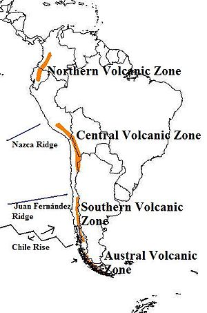
The andes mountains are one of the tallest. Map of the volcanic arcs in the Andes, and subducted structures affecting volcanism
The Andean Volcanic Belt is a major volcanic belt along the Andean cordillera in Argentina, Bolivia, Chile, Colombia, Ecuador, and Peru. It is formed as a result of subduction of the Nazca Plate and Antarctic Plate underneath the South American Plate. The belt is subdivided into four main volcanic zones which are separated by volcanic gaps. The volcanoes of the belt are diverse in terms of activity style, products, and morphology. While some differences can be explained by which volcanic zone a volcano belongs to, there are significant differences within volcanic zones and even between neighboring volcanoes. Despite being a type location for calc-alkalic and subduction volcanism, the Andean Volcanic Belt has a broad range of volcano-tectonic settings, as it has rift systems and extensional zones, transpressional faults, subduction of mid-ocean ridges and seamount chains as well as a large range of crustal thicknesses and magma ascent paths and different amounts of crustal assimilations.
Romeral in Colombia is the northernmost active member of the Andean Volcanic Belt. South of latitude 49° S within the Austral Volcanic Zone volcanic activity decreases with the southernmost volcano Fueguino in Tierra del Fuego archipelago. (Full article...) -
Ritacuba Blanco is the highest peak of Cordillera Oriental, in the Andes Mountains of Colombia. It's also named Ritak'uwa, an ancient name from the U'wa indigenous people that live in the lowlands of the National Park Sierra Nevada del Cocuy y Güicán, where the Ritacuba Blanco is located.
The summit is accessible from the west via the town of El Cocuy, the village of Güicán, and the hamlet of Las Cabañas. The hike is fairly easy, but the weather is not reliable, and a glacier must be crossed.
Because of global warming, its glacier is melting at very high rates, backing down 25 linear mts per year; the same is happening at amazing speeds to all other snow-covered tropical mountains in Colombia. In 1950, Ritacuba Blanco's glacier extended down to 4,100 metres (13,500 ft) above sea level; in January 2007 its lowest point was at 4,500 metres (14,800 ft) above sea level. If this melting rate continues, the glacier is expected to disappear before 2055. (Full article...) -
Cerro Castillo Dynevor, also known as Castillo Dynevor is located on the northwest coast of Skyring Sound, in Magallanes Region, Chile. It is named after its resemblance with Dynevor Castle in Wales, which was noticed by British explorers in 1830.
Its access is quite harsh due to the nature that all roads end about 30 km from it, and the rest of the way must be done either on a 4x4 vehicle, motorcycle, horse or on foot, either way the appropriate track is just by the shore, not through the woods, as they are too dense. (Full article...) -
Huayna Potosí is a mountain in Bolivia, located near El Alto and about 25 km north of La Paz in the Cordillera Real.
Huayna Potosí is the closest high mountain to La Paz. Surrounded by high mountains, it is roughly 15 miles due north of the city, which makes this mountain the most popular climb in Bolivia. The normal ascent route is a fairly straightforward glacier climb, with some crevasses and a steep climb to the summit. However, the other side of the mountain—Huayna Potosí West Face—is the biggest face in Bolivia. Several difficult snow and ice routes ascend this 1,000-meter-high face. (Full article...) -

The guanaco (/ɡwɑːˈnɑːkoʊ/ ghwuah-NAH-koh; Lama guanicoe) is a camelid native to South America, closely related to the llama. Guanacos are one of two wild South American camelids; the other species is the vicuña, which lives at higher elevations. (Full article...) -
Pico La Concha is a mountain in the Andes of Venezuela. It has a height of 4,922 metres. (Full article...) -

The royal cinclodes (Cinclodes aricomae) is a Critically Endangered passerine bird in the Furnariinae subfamily of the ovenbird family Furnariidae. It is found in Bolivia and Peru. (Full article...) -
Imbabura is an inactive stratovolcano in northern Ecuador. Although it has not erupted for about 7,500 years, it is not thought to be extinct. Imbabura is intermittently capped with snow and has no permanent glaciers.
Covered in volcanic ash, the slopes of Imbabura are especially fertile. In addition to cloud forests, which are found across the northern Andes to an altitude of 3000 m, the land around Imbabura is extensively farmed. Maize, sugarcane, and beans are all staple crops of the region. Cattle are also an important commodity, and much of the land on and around Imbabura, especially the high-altitude meadows above the tree line, is used for grazing. (Full article...) -
Cerro Escorial is a stratovolcano at the border of Argentina and Chile. It is part of the Corrida de Cori volcanic group and its youngest member. A well-preserved 1-kilometre-wide (0.6 mi) crater forms its summit area. Lava flows are found on the Chilean and smaller ones on the Argentinian side, the former reaching as far as 3–4 kilometres (1.9–2.5 mi) from the volcano. One of these is dated 342,000 years ago by argon-argon dating.
Off the western coast of South America, the Nazca Plate subducts beneath the South America Plate. This process has given rise to the Andes mountain chain and the Altiplano-Puna high plateau, which formed through shortening of the crust that lasted until 1 million years ago. Cerro Escorial rises from the Puna, which is dissected at Cerro Escorial by the Archibarca lineament; it is a strike-slip fault that has facilitated the ascent of magma. (Full article...) -
Nevado Tres Cruces is a massif of volcanic origin in the Andes Mountains on the border of Argentina and Chile. It has two main summits, Tres Cruces Sur at 6,748 metres (22,139 ft) and Tres Cruces Centro at 6,629 m (21,749 ft) and a third minor summit, Tres Cruces Norte 6,030 m (19,780 ft). Tres Cruces Sur is the sixth highest mountain in the Andes.
The volcano has an extended history of activity, going back at least 1.5 million years. A number of lava domes surround the complex and a number of craters lie on its summits. The main volcano is of rhyodacitic composition and has generated two major ignimbritic eruptions, one 1.5 million years ago and a second 67,000 years ago. The last eruption was 28,000 years ago, but the volcano is a candidate source for a Holocene eruption and could erupt again in the future. (Full article...) -

The Titicaca orestias, Lake Titicaca orestias, or Lake Titicaca flat-headed fish (Orestias cuvieri), also known by its native name amanto, is a likely extinct freshwater killifish from Lake Titicaca in South America. It belongs in the pupfish genus Orestias, endemic to lakes, rivers and streams in the Andean highlands. With a total length of up to 27 cm (10.6 in), it was the largest member in that genus. In the hope that an undiscovered population remains, it is listed as Data Deficient by the IUCN. Despite its common name, it is not the only Orestias from Lake Titicaca.
Its mouth was nearly turned upwards, thereby giving the flat head a concave shape. The head took up nearly a third of the whole body length. The upperside was greenish-yellow to umber. The lower jaw was black. Its scales were oddly light coloured at their centre. The scales of the young were blotched. (Full article...) -
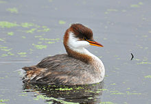
The Titicaca grebe (Rollandia microptera), also known as the Titicaca flightless grebe or short-winged grebe, is a grebe found on the altiplano of Peru and Bolivia. As its name implies, its main population occurs on Lake Titicaca. Lake Uru Uru and Poopó, the Rio Desaguadero, and small lakes that connect to Lake Titicaca in wet years, serve as "spillovers" territory. In the past, the population was larger and several of these lakes – such as Lakes Umayo and Arapa – apparently had and may still have permanent large colonies (BirdLife International 2006). It is sometimes placed in Podiceps or a monotypic genus Centropelma. Its local name is zampullín del Titicaca. (Full article...) -
The Cordillera Paine is a mountain group in Torres del Paine National Park in Chilean Patagonia. The cordillera is located 280 km (170 mi) north of Punta Arenas, and about 1,960 km (1,220 mi) south of the Chilean capital Santiago. It belongs to the Commune of Torres del Paine in Última Esperanza Province of Magallanes and Antártica Chilena Region. No accurate surveys have been published, and published elevations have been claimed to be seriously inflated, so most of the elevations given on this page are approximate. Paine means "blue" in the native Tehuelche (Aonikenk) language and is pronounced PIE-nay. (Full article...) -
Mount Tarn is a small mountain located on the southernmost part of the Strait of Magellan, in Brunswick Peninsula, about 70 km south of Punta Arenas, Chile. It is in the southern extreme of continental Chile very close to Cape Froward, surrounded by historic places such as Fort Bulnes and Puerto del Hambre (Port Famine).
From the summit it is possible to see the Strait of Magellan, Dawson and Tierra del Fuego islands, and many other smaller ones; the Darwin Mountain Range, Mount Sarmiento, and most of the Brunswick Peninsula. (Full article...) -
The Junin grebe (Podiceps taczanowskii), also known as Junin flightless grebe or puna grebe, is a species of grebe endemic to Lake Junin in the Andean highlands of Junin in west-central Peru. An endangered species, the current population is estimated at 300–400 individuals, including 140–320 adults. (Full article...) -
Los Nevados National Natural Park (Spanish: Parque Nacional Natural Los Nevados) is a national park located in the Cordillera Central of the Colombian Andes. The park surrounds the northern volcanic complex formed by Nevado del Ruiz, Nevado del Tolima, Nevado de Santa Isabel, the paramillos of Cisne, Santa Rosa and Quindío and the Cerro Bravo and Cerro Machín.
The park is located in the departments of Caldas, Quindío, Risaralda, Tolima and spans between the municipalities Manizales, Villamaría, Santa Rosa de Cabal, Pereira, Salento, Villahermosa, Anzoátegui, Santa Isabel, Murillo, Ibagué and Casabianca. (Full article...) -
Orestias chungarensis is a species of fish in the family Cyprinodontidae. It is endemic to Lake Chungara in Chile. (Full article...)
-
Patilla Pata is a stratovolcano in the Oruro Department in Bolivia. It is situated in the Sajama Province, in the west of the Curahuara de Carangas Municipality, at the border with Chile. Patilla Pata lies south-west of the mountain Jisk'a Kunturiri, north-east of the lake Q'asiri Quta (Khasiri Kkota) and the mountain Qullqi Warani, west of the little lake Sura Pata, south-east of the mountains Laram Q'awa, Kunturiri and Milluni and south of the little lake named Ch'iyar Quta.
The river Junt'uma K'uchu (Aymara junt'u warm, hot, uma water, k'uchu corner, "warm water corner", Junthuma Khuchu) originates south of Patilla Pata. It flows to the south-east as a right affluent of the Sajama River. (Full article...) -

Nevado Sajama ([neˈβaðo saˈxama]; Aymara: Chak Xaña) is an extinct volcano and the highest peak in Bolivia. The mountain is located in Sajama Province, in Oruro Department. It is situated in Sajama National Park and is a composite volcano consisting of a stratovolcano on top of several lava domes. It is not clear when it erupted last but it may have been during the Pleistocene or Holocene.
The mountain is covered by an ice cap, and Polylepis tarapacana trees occur up to 5,000 metres (16,000 ft) elevation. (Full article...) -
Mount Hudson (Spanish: Volcán Hudson, Spanish: Cerro Hudson, Monte Hudson) is a volcano in the rugged mountains of southern Chile. Lying in the Southern Volcanic Zone of the Andes, it was formed by the subduction of the oceanic Nazca Plate under the continental South American Plate. The Nazca Plate ends there at the Chile Triple Junction; south of Hudson is a smaller volcano, followed by a long gap without active volcanoes that separates the Southern Volcanic Zone from the Austral Volcanic Zone. Hudson has the form of a 10-kilometre-wide (6-mile) volcanic caldera filled with ice. The Huemules Glacier emerges from the northwestern side of the caldera. The volcano has erupted rocks ranging from basalt to rhyolite, but large parts of the caldera are formed by non-volcanic rocks.
The volcano erupted numerous times in the late Pleistocene and Holocene, forming widespread tephra deposits both in the proximity of Hudson and in the wider region, and is the most active volcano in the region. The last eruption was in 2011. (Full article...) -
The Wet Andes (Spanish: Andes húmedos) is a climatic and glaciological subregion of the Andes. Together with the Dry Andes it is one of the two subregions of the Argentine and Chilean Andes. The Wet Andes runs from a latitude of 35°S to Cape Horn at 56°S. According to Luis Lliboutry the Wet Andes can be classified after the absence of penitentes. In Argentina well developed penitentes are found as south as on Lanín Volcano (40°S). Another difference is that the Wet Andes is largely devoid of rock glaciers. The glaciers of the Wet Andes have a far more stable line of equilibrium than those of the Dry Andes due to summer precipitations, low thermal oscillations and an overall high moisture. (Full article...)


-2.JPG)


Did you know...
- ... that the 1930s Polish Andean expeditions have been credited with several first ascents and the tracing of a new route to the summit of Aconcagua, the Andes' highest peak?
Need help?
Do you have a question about Andes that you can't find the answer to?
Consider asking it at the Wikipedia reference desk.
General images
-
 Peruvian farmers sowing maize and beans (from Andes)
 -
 Parinacota, Bolivia/Chile (from Andes)
 -
 Map of a north-south sea-parallel pattern of rock ages in western Colombia. This pattern is a result of the Andean orogeny. (from Andean orogeny)
 -
 Simplified sketch of the present-situation along most of the Andes (from Andean orogeny)
 -
 Mashua tubers (from Andean agriculture)
 -

-
 Nevado del Huila, Colombia (from Andes)
 -

-
 View of Cuernos del Paine in Torres del Paine National Park, Chile (from Andes)
 -
 Laguna de Sonso tropical dry forest in Northern Andes (from Andes)
 -
 Paleogeography of the Late Cretaceous South America. Areas subject to the Andean orogeny are shown in light grey while the stable cratons are shown as grey squares. The sedimentary formations of Los Alamitos and La Colonia that formed in the Late Cretaceous are indicated. (from Andean orogeny)
 -

-
 Bolivian Andes (from Andes)
 -

-
 Frederic Edwin Church, Heart of the Andes, 1859. (from Andes)
 -
 Ulluco: Common crop of the Andean region (from Andean agriculture)
 -

-
 Topographic map of the Andes by the NASA. The southern and northern ends of the Andes are not shown. The Bolivian Orocline is visible as a bend in the coastline and the Andes lower half of the map. (from Andean orogeny)
 -

-
 Aerial view of Valle Carbajal in the Tierra del Fuego. The Andes range is about 200 km (124 mi) wide throughout its length, except in the Bolivian flexure where it is about 640 kilometres (398 mi) wide. (from Andes)
 -

-

-
 Map of the Andean region of South America (from Andean agriculture)
 -
 Irrigating land in the Peruvian Andes (from Andes)
 -
 A male Andean cock-of-the-rock, a species found in humid Andean forests and the national bird of Peru (from Andes)
 -
 Pacha Mama Ceremony (from Andean agriculture)
 -

-

-
 Syncline next to Nordenskjöld Lake in Torres del Paine National Park. The syncline formed during the Andean orogeny. (from Andean orogeny)
 -
 Central Andes (from Andes)
 -
 The seaward tilting of the sedimentary strata of Salto del Fraile Formation in Peru was caused by the Andean orogeny. (from Andean orogeny)
 -
 Pico Humboldt at sunset (from Andes)
 -


.JPG)

.jpg)


.jpg)
.jpg)


%E2%80%93Valle_Carbajal_01.jpg)


.jpg)


Subcategories

- Select [►] to view subcategories
Related portals
Subtopics
Associated Wikimedia
The following Wikimedia Foundation sister projects provide more on this subject:
-
 Commons
Free media repository -
 Wikibooks
Free textbooks and manuals -
 Wikidata
Free knowledge base -
 Wikinews
Free-content news -
 Wikiquote
Collection of quotations -
 Wikisource
Free-content library -
 Wikiversity
Free learning tools -
 Wiktionary
Dictionary and thesaurus


