Portal:Peru
Introduction
Peru, officially the Republic of Peru, is a country in western South America. It is bordered in the north by Ecuador and Colombia, in the east by Brazil, in the southeast by Bolivia, in the south by Chile, and in the south and west by the Pacific Ocean. Peru is a megadiverse country with habitats ranging from the arid plains of the Pacific coastal region in the west to the peaks of the Andes mountains extending from the north to the southeast of the country to the tropical Amazon basin rainforest in the east with the Amazon River. Peru has a population of over 32 million, and its capital and largest city is Lima. At 1,285,216 km2 (496,225 sq mi), Peru is the 19th largest country in the world, and the third largest in South America. Peruvian territory was home to several cultures during the ancient and medieval periods, and has one of the longest histories of civilization of any country, tracing its heritage back to the 10th millennium BCE. Notable pre-colonial cultures and civilizations include the Caral–Supe civilization (the earliest civilization in the Americas and considered one of the cradles of civilization), the Nazca culture, the Wari and Tiwanaku empires, the Kingdom of Cusco, and the Inca Empire, the largest known state in the pre-Columbian Americas. The Spanish Empire conquered the region in the 16th century and Charles V established a viceroyalty with the official name of the Kingdom of Peru that encompassed most of its South American territories, with its capital in Lima. Higher education started in the Americas with the official establishment of the National University of San Marcos in Lima in 1551. Peru's population includes Mestizos, Amerindians, Europeans, Africans and Asians. The main spoken language is Spanish, although a significant number of Peruvians speak Quechuan languages, Aymara, or other Indigenous languages. This mixture of cultural traditions has resulted in a wide diversity of expressions in fields such as art, cuisine, literature, and music. (Full article...) Entries here consist of Good and Featured articles, which meet a core set of high editorial standards.
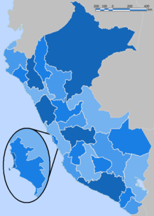 According to the Organic Law of Regional Governments, the regions (Spanish: regiones) are, with the departments, the first-level administrative subdivisions of Peru. Since its 1821 independence, Peru had been divided into departments (departamentos) but faced the problem of increasing centralization of political and economic power in its capital, Lima. After several unsuccessful regionalization attempts, the national government decided to temporarily provide the departments (including the Constitutional Province of Callao) with regional governments until the conformation of regions according to the Organic Law of Regional Governments which says that two or more departments should merge to conform a region. This situation turned the departments into de facto regional government circumscriptions. The first regional governments were elected on November 20, 2002. (Full article...)Selected image Photo credit: Bcasterline
Amantaní is an island on the Peruvian side of Lake Titicaca. According to a 1988 census, it has a population of 3,663 Quechua speakers divided among about 800 families. The island is circular and about 9.28 km² in size. It has two mountain peaks, Pachatata (Father Earth) and Pachamama (Mother Earth), with ancient Inca and Tiwanaku ruins on top of both. The hillsides, are terraced mostly worked by hand and planted with wheat, quinoa, potatoes, and other vegetables. Livestock, including alpacas, also graze the slopes. (more...) Selected battleThe Siege of Cuzco (May 6, 1536 – March 1537) was the ten month siege of the city of Cuzco by the army of Inca Emperor Manco Inca Yupanqui against a garrison of Spanish conquistadors and Indian auxiliaries led by Hernando Pizarro. An Spaniard expedition led by Francisco Pizarro had captured the Inca capital of Cuzco on November 15, 1533 after defeating an Inca army headed by general Quisquis. The following month, the conquistadors supported the coronation as Inca emperor of Manco Inca to facilitate their control over the empire. However, real power rested with the Spaniards who frequently humiliated Manco Inca and imprisoned him after an attempted escape in November 1535. After his release in January 1536, Manco Inca managed to leave Cuzco on April 18 promising the Spanish commander, Hernando Pizarro, to bring back a large gold statue when in fact he was already preparing a rebellion. (more...) In this month
General imagesThe following are images from various Peru-related articles on Wikipedia.
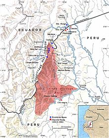
Selected article -The Cenepa War or Fourth Ecuadorian-Peruvian War (26 January – 28 February 1995), also known as the Alto Cenepa War, was a brief and localized military conflict between Ecuador and Peru, fought over control of an area in Peruvian territory (i.e. in the eastern side of the Cordillera del Cóndor, Province of Condorcanqui, Región Amazonas, Republic of Perú) near the border between the two countries. The two nations had signed a border treaty following the Ecuadorian–Peruvian War of 1941, but Ecuador later disagreed with the treaty as it applied to the Cenepa and Paquisha areas, and in 1960 it declared the treaty null and void. Most of the fighting took place around the headwaters of the Cenepa River. Mediation efforts of Argentina, Brazil, Chile and the United States paved the way for the opening of diplomatic conversations that ultimately led to the signing of a definitive peace agreement (the Brasilia Presidential Act) on 26 October 1998. The peace agreement saw some of the territory being leased to Ecuador for a time. It was followed by the formal demarcation of the border on 13 May 1999 and the end of the multinational MOMEP (Military Observer Mission for Ecuador and Peru) troop deployment on 17 June 1999, which effectively put an end to one of the longest territorial disputes in the Western Hemisphere. (Full article...)Did you know (auto-generated) -
CategoriesRelated portalsSelected quote -
English art historian, writer, antiquarian and politician Horace Walpole 1717–1797
Basic facts & figuresMore did you know...
Peru TopicsRecognized content
Featured articlesFeatured listsGood articles
WikiProjectsThings you can do
New articlesThis list was generated from these rules. Questions and feedback are always welcome! The search is being run daily with the most recent ~14 days of results. Note: Some articles may not be relevant to this project.
Rules | Match log | Results page (for watching) | Last updated: 2024-05-20 23:05 (UTC) Note: The list display can now be customized by each user. See List display personalization for details.
Associated WikimediaThe following Wikimedia Foundation sister projects provide more on this subject:
Discover Wikipedia using portals | |||||||||||||||


