Taroudant
Taroudant
| |
|---|---|
Taroudant | |
| Coordinates: 30°28′15.59″N 8°52′50.16″W / 30.4709972°N 8.8806000°W | |
| Country | |
| Region | Souss-Massa |
| Province | Taroudant |
| Elevation | 238 m (781 ft) |
| Population (2014)[1] | |
| • Total | 80,149 |
| Time zone | UTC+0 (WET) |
| • Summer (DST) | UTC+1 (WEST) |
| Postal code | 83000 |
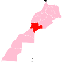
Taroudant (Moroccan Arabic: تارودانت, romanized: Tarudant, [taːruːdaːnt]; Tachelhit: ⵜⴰⵔⵓⴷⴰⵏⵜ) is a city in the Sous in southwestern Morocco. It is situated east of Agadir on the road to Ouarzazate and south of Marrakesh. Today, it is a small market town and a tourist destination.[2][3]
History[edit]

The Almoravids occupied the town in 1056.[2] In the mid-15th century the Banu Zaydan, the family who later founded the Saadi dynasty, established themselves near Taroudant in a settlement called Tidsi, which served briefly as the base of the dynasty's first leader, al-Qa'im, until 1513.[4][5][6] According to Moroccan news media, the current layout of the city walls dates to the Saadi period in the 16th century.[3]
In the 17th century, Taroudant was the base of Sidi Yahya, a local chieftain who successfully aided the Saadi sultan Moulay Zaydan against Abu Mahalli, a rebel who had captured Marrakesh.[7]
The city underwent economic decline after the port of Agadir was closed to commerce in 1760.[7] In the late 19th century, Sultan Hassan I established more secure control of the city. At the beginning of the 20th century it resisted government control again until qa'id Tayyeb al-Goundafi restored order in 1903.[7] When France began to impose its protectorate on Morocco in 1912, Ahmed al-Hiba used Taroudant as his capital to resist the French. The French only established control over it in 1917.[7]
Historically, there was a Jewish community in Taroudant, believed to have been established in the 11th century. Jews made up 10% of the city's population, and mainly engaged in the caravan trade.[8]
Climate[edit]
On 8 July 2022, a maximum temperature of 47.8 °C (118.0 °F) was registered.[9][relevant?]
Economy[edit]
Today, Taroudant is a notable market town with a souk near each of its two main squares, Assarag and Talmoklate. There is also a weekly souk outside the city walls, near the future university district.[2]
Landmarks[edit]
The medina (historic quarter) of Taroudant is classified as a national cultural heritage monument of Morocco.[10] Its historic city walls are around 6 kilometres (3.7 mi)[2] or 8 kilometres (5.0 mi)[3] long and are set with bastions and punctuated by nine gates that are still in use.[2]
Notable people[edit]
- Sana Akroud (born 1980), actress, filmmaker, screenwriter, film producer
- Moses ben Maimon Albas (16th century), kabbalist
- Ahmed Soultan, singer
References[edit]
- ^ "Population légale des régions, provinces, préfectures, municipalités, arrondissements et communes du royaume d'après les résultats du rgph 2014" (in Arabic and French). High Commission for Planning, Morocco. 8 April 2015. Retrieved 29 September 2017.
- ^ a b c d e Morocco. Eyewitness Travel Guides, Dorling Kindersley. 2006. p. 288.
- ^ a b c "Marrakech's Taroudant: A Small Town Full of History and Charm". Morocco World News. 27 October 2018. Retrieved 17 November 2019.
- ^ Deverdun, Gaston (1959). Marrakech: Des origines à 1912 (in French). Rabat: Éditions Techniques Nord-Africaines. p. 350.
- ^ Abun-Nasr, Jamil (1987). A history of the Maghrib in the Islamic period. Cambridge: Cambridge University Press. p. 210. ISBN 0-521-33767-4.
- ^ Boum, Aomar; Park, Thomas K. (2016). "Sa'dian dynasty". Historical Dictionary of Morocco. Rowman & Littlefield. p. 432. ISBN 978-1-4422-6297-3.
- ^ a b c d Boum, Aomar; Park, Thomas K. (2016). "Taroudant". Historical Dictionary of Morocco. Rowman & Littlefield. p. 458. ISBN 978-1-4422-6297-3.
- ^ "Discover Morocco's Berber Jewish Past". The Times of Israel. Retrieved 6 June 2024.
- ^ "60253: Taroudant (Morocco)". ogimet.com. OGIMET. 8 July 2022. Retrieved 10 July 2022.
- ^ "Médina de Taroudannt". Inventaire du patrimoine culturel du Maroc (in French). Archived from the original on 2019-11-17. Retrieved 2019-11-17.


