
Volcanic Legacy Scenic Byway
This article about roads may need to be written in a south-to-north or west-to-east direction. |
Volcanic Legacy Scenic Byway | |
|---|---|
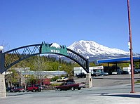
 Lassen Peak from the Volcanic Legacy Scenic Byway | |
| Route information | |
| Length | 500 mi (800 km) |
| Main byway | |
| North end | |
| South end | |
| Tule Lake spur route | |
| North end | |
| South end | Lava Beds National Monument |
| Lassen Scenic Byway (loop road) | |
| From | |
| From | |
| Lassen Scenic Byway bypass | |
| From | |
| From | |
| Location | |
| Country | United States |
| States | California and Oregon |
| Highway system | |
The Volcanic Legacy Scenic Byway is a scenic byway and All-American Road in the U.S. states of California and Oregon. It is roughly 500 mi (804.7 km) long and travels north–south along the Cascade Range past numerous volcanoes. It is composed of two separate National Scenic Byways, the Volcanic Legacy Scenic Byway - Oregon and Volcanic Legacy Scenic Byway - California. The latter also wholly includes the Lassen Scenic Byway.[1]
Route description[edit]
California section[edit]
- Region 1 through Region 4: the Lassen Scenic Byway
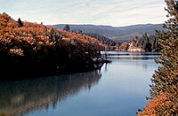
The southern terminus of the byway is located in Canyondam, at the intersection of Route 147 and Route 89. Route 89 runs along the west side of Lake Almanor, and then runs eastward through Chester towards Mineral. From Mineral, the byway runs northward through Lassen Volcanic National Park to Manzanita Lake to Old Station. From the southern terminus of the byway, there is also a bypass route along Route 147. Route 147 runs along the east side of Lake Almanor and intersects with Route 36 at Westwood. From this point, the bypass runs eastward until it intersects with Route 44 in Susanville. From this point, the bypass runs to the northwest through the Lassen National Forest until it intersects with Route 89 in Old Station. The route from Canyondam to Chester to Mineral to Manzanita Lake to Old Station to Susanville to Westwood and back to Canyondam forms a loop—designated the Lassen Scenic Byway—which can be traveled either clockwise or counterclockwise.
- Region 5: Old Station through Lake Britton
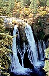
Continuing northwards from Old Station, the byway goes through Hat Creek, then McArthur–Burney Falls Memorial State Park and Lake Britton. Thousand Lakes Wilderness and Burney Mountain are located just west of the byway, while the Lassen National Forest is to the west.
- Region 6: Lake Britton through Weed
Continuing northwards from Lake Britton, the byway goes through part of the Shasta–Trinity National Forest, then McCloud, then Mount Shasta, then through Black Butte to Weed. Lake Siskiyou is located just west of the byway, while Mount Shasta is to the west.
Continuing northwards from Weed, the byway goes past Carrick, then Pluto's Cave, Mount Hebron, Macdoel, Butte Valley National Grassland, and Meiss Lake before arriving at Dorris. Just north of Dorris, a spur route runs east along the California–Oregon state line on Route 161 past Ainsworth Corner to Hatfield. At Hatfield, Route 161 joins Route 139. From here, the byway continues south to Tulelake. At this point, Route 139 becomes the Lava Beds Highway. There are many interesting places along this section of the byway, including Lower Klamath National Wildlife Refuge, Tule Lake National Wildlife Refuge on the western shore of Tule Lake, Camp Tulelake, Tule Lake Relocation Center, Lava Beds National Monument, and Medicine Lake Volcano.
Oregon section[edit]
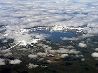
Starting at U.S. Route 97 south of Chemult, the byway heads west on Oregon Route 138 before turning south on Oregon Route 209 into Crater Lake National Park, where Crater Lake fills the caldera of the destroyed Mount Mazama volcano. The byway includes Rim Drive which circumnavigates the lake.
South of Crater Lake, the byway continues down Oregon Route 62, with Mount Scott on the east, to Fort Klamath, whereupon it heads west on Weed Road to Sevenmile Road, then south on West Side Road along the edge of the Upper Klamath National Wildlife Refuge and Upper Klamath Lake. The byway then passes Mount McLoughlin on the east as it joins Oregon Route 140 to Klamath Falls.
From there, the route proceeds southwards on US 97, between Bear Valley National Wildlife Refuge and Lower Klamath National Wildlife Refuge to the California border.
Gallery[edit]
-
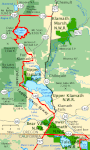
 Map of California section
 -
 Map of Oregon section
 -
-

-

-
-
-

-


.jpg)


See also[edit]
References[edit]
External links[edit]
- All-American Roads
- Crater Lake National Park
- Named highways in California
- Protected areas of Lassen County, California
- Protected areas of Plumas County, California
- Protected areas of Shasta County, California
- Protected areas of Tehama County, California
- Roads in Lassen County, California
- Roads in Plumas County, California
- Roads in Shasta County, California
- Roads in Siskiyou County, California
- Roads in Tehama County, California
- Scenic highways in Oregon
- State Scenic Highway System (California)
- Transportation in Klamath County, Oregon
- U.S. Route 97
- Volcanism of California
- Volcanism of Oregon